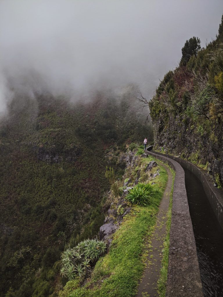
Madeira Island is a little-known hiking destination in Europe. From easy day hikes via levadas, forest and coastal routes to steep mountain treks that can be combined into multi-day trails. Each and every trail offers jaw-dropping moments with vast mountain views, waterfalls, canyons, and clouds that add mystique to the hikes.
With constantly good weather it is a perfect hiking island throughout the year. This guide will outline all you need to know for having an awesome hiking trip
Table of Contents
How to get to Madeira
There are only 2 ways of getting to the island.
By boat – [As of 2020 because of COVID it was temporarily closed.] There is 1 ferry route running between Madeira Islands and Portugal operated by 1 ferry company – Porto Santo Line. The Funchal to Porto Santo ferry crossing operates weekly with a scheduled sailing duration of about 2 hours 30 minutes.
The cost is around 222 dollars per person.
By plane – The easiest and the most flexible way. Almost all cheap airlines fly to Madeira. You can see the locations from where the direct flights happen and which airlines fly to Madeira by visiting flight connections website.
Prices can vary anywhere from 60 to 500+ dollars per person.
How to get around the island
There are 4 main ways of getting around the island.
By taxi – There are few companies offering services. You can get local yellow taxis on the street but is the most expensive option. Uber is a cheaper option, but Bolt and Taxiin apps offer the cheapest options of them all. However, only Taxiin can deliver a driver almost anywhere on the island.
By car – There are a few places where you can rent a car from including Wizz Air or Ryanair pages. If you feel like supporting local business (prices as good as Wizzair but car delivery and drop off wherever you want) you can try xtracars.
By bus – This is mostly good for the Funchal area. Getting around the island is complicated and only a few buses go throughout the day. They are good at getting to the spot and overnighting but not really exploring the island in one go.
On foot – Not on the main roads but via mountains. It is the cheapest option but the most time demanding one. The upside? It is green and has incredible views.
Places to get hiking gear on Madeira
There is really just one city that you can get all your gear needs and that is in Funchal – the capital of the island. There are two main places you can get all the gear you need.
My favorite and one of the cheapest ones is Decathlon. They have high-quality products for cheap prices. You can find the store at Azinhaga do Poço Barral nº 14, 9000-638 Funchal.
O Bordão is the island’s only dedicated outdoor gear shop. The range is limited and prices aren’t exactly low, but it’s just the place to solve a kit emergency. You can find the store at Avenida Arriaga 33-47 Galerias São Lourenço, Loja 35, R/C, 9000-060 Funchal.
Best spots to base yourself for hikes

The best spot for any hikes would be Funchal. It is the largest city on the island that has everything you need in one spot. Also, there are some exciting hiking trails that start right in Funchal, such as Levada do Curral and Pico Alto e Poiso via Levada das Cales.
However, if you are running away from the noise of the cities these spots are quite remote and more difficult to get around without a car but the views and small village vibes make them worthwhile.
Seixal is a beautiful little village with a black sandy beach. They have few restaurants and natural lava pools. It’s quiet and remote and is perfect for anyone who is looking to run away. It really is a little heaven on earth.
Ponta Do Sol is another small picturesque village. It’s the type you would imagine when people say Portugal and a colonial village. It has around 100km of trails that can be started from the village, making it ideal for hikers. There is an active digital nomad community if you ever need company or people to go on a hiking trip as well.
Machico – a magnificent little village with an artificial sandy beach perfect for surfing and hiking. For those who want a larger village than a few hundred people.
Cost of living and hiking in Madeira
It can be both expensive and cheap to live in Madeira. It all depends on your desires. But it is possible to find a place to rent from 600 dollars but the rent price can go as high as 1800 per month. Usually, rent will be the biggest deciding factor in how much your stay in Madeira will cost (unless you decide to eat out all the time). Other costs include:
- Food (if you are cooking) is around 380 USD per month for 2 people.
- Restaurant prices per meal for 2 are between 25-60 USD. Small village restaurants tend to be more expensive than the capital.
- Taxi price is roughly 1km = 1.20 USD.
- Basic gear from Decathlon – tent, mattress, sleeping bag, utensils and other minor hiking items will be around 250 USD. Good for 2-7 day hikes.
- Car rental prices are around 480 USD per month with insurance included.
Mine and girlfriend’s personal spending per month is:
- Rent – 715 USD
- Food – 380 USD
- Hiking – 250 USD
Disclosure – We work from Monday till Friday.
Weather in Madeira
Weather in Madeira is a constant spring with a twinge of summer and a little bit of late fall. However, don’t be fooled by it. You can get all three seasons in one day. The weather in the mountains changes quickly from sunny to cloudy to rainy all on the same day. In winter weather can get below zero in the mountains.
Gear required for day hikes in Madeira

For day hikes I would advise taking these essentials, plus a few extras depending on your hiking level.
- A daypack
- A wind jacket
- A rain poncho
- Snacks
- Pants
- Trail runners or hiking shoes
- Socks
- Walking stick
- Water
- Paper map
- Phone with a map – https://www.gaiagps.com/
- Warm fleece
Other suggestable items you can find on my other post I wrote 14 daypack hiking essentials.
Gear required for multi-day hikes in Madeira
 Gear for multi-day hikes I would advise include all the above plus the ones below:
- A backpack instead of a daypack
- Tent
- Sleeping pad
- Sleeping bag
- Cooking equipment
- Thermo pants for sleeping
- Knife
- Rope
- Food
- First Aid Kit
Key Info To know Before Hiking Madeira
- Before going on a hike make sure you know your campsite locations. It is illegal to wild camp wherever you want and there is actual mountain police looking for illegal campers. Fines go from 240 to 1200 USD. Official campsites can be found on the Madeira Camping website and also if you would like to do wild camping you can request permission from the government.
- Check if the trail is opened and safe to hike on walkmeguide website. There are also lots of webcams around the island that can help you decide whether it’s a good moment for a certain hike regarding weather conditions.
- Should you take a guide? It’s a yes and no. If you are doing an easy hike, you can do it alone. If you’re planning to do something more adventurous and you are a beginner hiker it is always advisable to have a guide. A great guide is Joao Let’s Go Hiking.
- Trash should be carried with you all the time and then thrown out at the nearest trash bin.
- Inform someone where you are going, your planned itinerary and also when you are coming back.
- Be prepared for all types of weather.
Type of hikes available on the island
Day trails
There is over 2000km of hikeable trails and to list them all would take ages. But luckily someone has done most of it already and you can find all the trails here. However, I would like to share with you some of my most favorite, beautiful, and exciting hikes right here.
Exciting and easy hikes
Trail map: Ponta de São Lourenço

Ponta de São Lourenço is the easternmost point on the island and one of the most popular hikes on Madeira. It’s not overly long or difficult but offers incredible views for most of the way. The hike is a 7.5km return along the long thin edge of the peninsula.
- Length – 7.5 km
- Elevation gain – 411 m
- Route type – Out & back
- Start and Finish – ER109, Estr. de São Lourenço, 9200-044 Caniçal, Portugal
Trail map: Levada do Moinho to Levada Nova

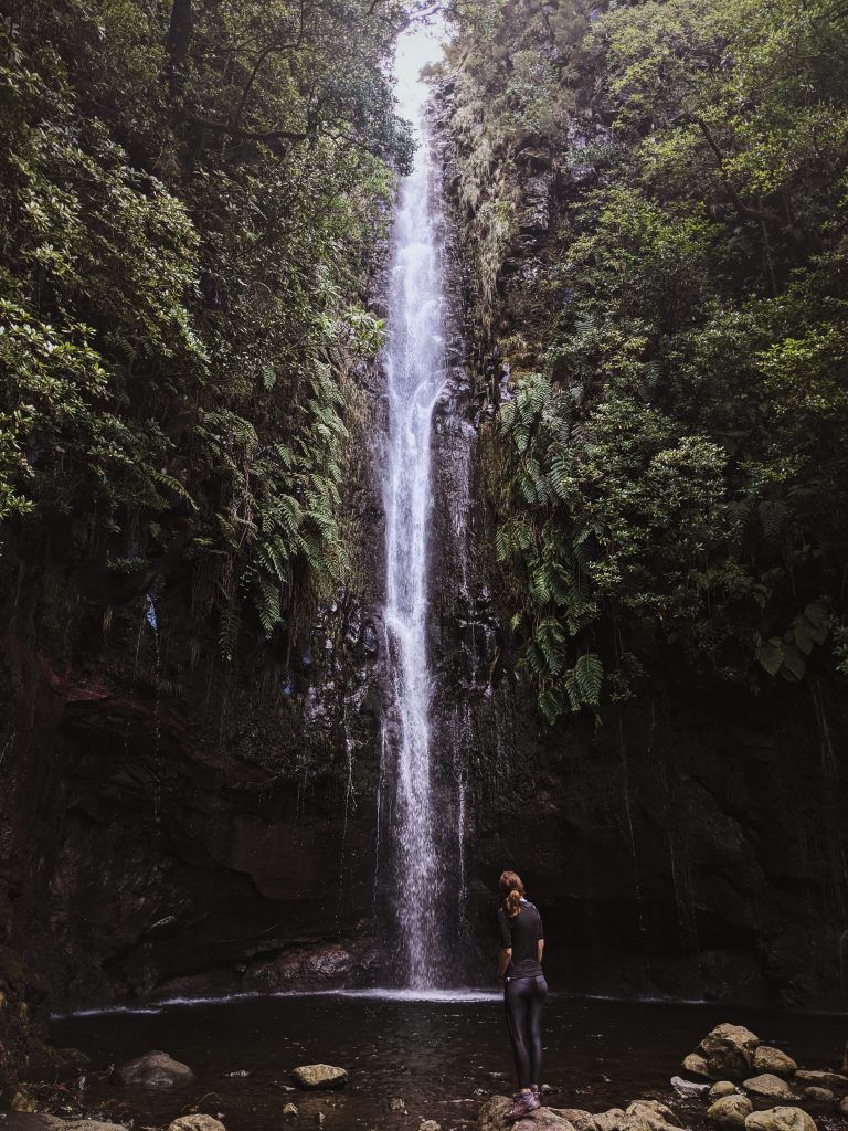
This moderate loop starts near the Church of the Lombada and offers beautiful views over the valley and farmland. The highlight of this hike though is the waterfall which you can enjoy after some steep climbing. The 14.5km loop is not entirely secure, you’ll need to be sure-footed and careful on the edges, but it’s a popular trail used by families as well.
- Length – 14.5 km
- Elevation gain – 1005 m
- Route type – Loop
- Start and finish – Casa Paroquial 24, Ponta do Sol, Portugal
Trail map: Levada Nova via Ribeira Brava

As an alternative and more difficult way of reaching the Levada Nova waterfall, this 23.5km return hike begins near Rebeira Brava. This is a much more challenging option but offers views across the town and towards the ocean. You will need to make sure you’re well prepared for this hike, but the waterfall at the top is worth the effort.
- Length – 23.5km
- Elevation gain – 1208 m
- Route type – Out & back
- Start and finish – Caminho da Apresentação, Tabua, Portugal
Fun and moderate difficulty hikes
Trail map: Levada do Paul – Levada da Bica da Cana

This skinny, return trail is high up above Canhas. It skirts around the mountains offering beautiful views across the farmland, towns and coastline of southern Madeira. The moderate walk is most well known for its incredible wildflowers with photographers often flocking there when the weather is right.
- Length – 16.5 km
- Elevation gain – 540 m
- Route type – Out & back
- Start and finish – ER209, Ribeira da Janela, Portugal (32.74013950702969, -17.102444256812635)
Trail map: Caminho Terra Cha
This incredibly scenic hike is less popular than some of the others mentioned on this list but is equally stunning. The 4.7km moderate trail on the northeastern part of Porto Santo Island. The return hike is good for a range of fitness levels and offers an incredible dramatic trail against steep cliffs. There is a safety barrier built for much of the walk, as the steep drop can seem quite daunting otherwise.
- Length – 4.7 km
- Elevation gain – 422 m
- Route type – Out & back
- Start and Finish – ER111, Vila Baleira, Portugal (33.0967503075845, -16.314617307480802)
Rewarding and hard hikes
Trail map: Pico do Arieiro – Pico Ruivo

This is arguably one of the more beautiful hikes on the islands. It’s located right in the center of Madeira north of Funchal. The 11km return hike begins at the incredibly stunning lookout of Pico do Arieiro. The panoramic views overlook beautiful rugged mountains with skinny trails navigating the jagged ridgelines. While the steps on this hike offer steep drops, there are safety rails for much of it. It’s definitely a rewarding hike that you won’t forget.
- Length – 11 km
- Elevation gain – 1180 m
- Route type – Out & back
- Start and finish – 32.7356377270961, -16.928882672069395
Trail map: Ponta do Sol a Ponta Delgada
For a truly demanding hike that requires an entire day of your time, this point-to-point trail crosses the Madeira island from Ponta do Sol to Ponta Delgada. It’s an epic 30km hike that is quite difficult and takes in all of the best views across the entire island. There are some steep sections, as well as plenty of steps. If you’re looking for a challenging but rewarding day out, this is one of the best Madeira hiking trails.
- Length – 30 km
- Elevation gain – 1976 m
- Route type – Point to point
- Start – 32.7356377270961, -16.928882672069395
Trail map: Vereda da Terra Chã

This challenging 14km return hike is on the northern side of the island near Seixal. It requires a steady climb through a forest that can be tough on your legs, but you finally get a view of the valley at the top. It’s a lesser-known hike so if you prefer quieter trails, this is one for you.
- Length – 14 km
- Elevation gain – 1351 m
- Route type – Out & back
- Star and finish – 32.7356377270961, -16.928882672069395
Trail Map/Guide – São Vicente to Ponta Do Sol (My Own Custom Trail)

This is one of the personally created custom trails by me. It is a demanding hike that requires an entire day of your time. It’s a challenging 30km hike that is quite difficult and passes through some of the most beautiful levadas on the island. There are steep sections, plenty of tunnels, jaw-dropping cliffs, and certain rarely walked trails, not on the official trail lists. Some sections have no safety rails, have tight walks and are best done with good weather. Since strong winds or rain can get you off balance and off-trail. If you’re looking for a challenging, a bit dangerous but rewarding day out, this is the one.
- Length – 30 km
- Elevation gain – 1400 m
- Route type – Point to point
- Start – 32.780090, -17.046796
- Hike Responsibly!
Ponta Do Sol to Ponta Do Sol (Custom Trail/Guide In The Works)

Another custom trail. It’s a challenging 30km hike that is quite difficult. Starting at 0 sea level and rising to 1400m. It is a 3 to 4 hour climb before you reach the highest point of the hike. There are sections that go via old trails that are long overgrown and difficult to find. It is best for hikers that know how to read the compass, map and nature in finding the trail and direction to hike while on the overgrown trails. But once you go above the clouds you understand that this trail will be simply a jawbreaker.
- Length – 30 km
- Elevation gain – 1400 m
- Route type – Loop
- Start – 32.780090, -17.046796
- Hike Responsibly!
Multi-day hikes
There are a few official multi-day trails. However, the best part of Madeira is that you can plan your own multi-day hikes via routes that you think would be the most interesting. One thing to be aware of while planning hikes is to be sure you know where to pitch the tent. Because the island has such rugged mountains with steep cliffs it is difficult to find camping spots on the way. It is best to know where exactly you will camp before you set out.
Trail map: Rota Circular de Madeira

If you want to take the entire island on a hike, then this trail is for you. The epic trail is over 300km and forms a loop from Santa Cruz on Madeira. It’s only recommended for very experienced hikers, who have experience in multi-day hikes and thru-hikes. It makes a loop around the island in a clockwise direction and then makes a trip out to the easternmost peninsula as well. It requires a lot of planning. If you don’t want to hike on the road and have high-quality gear it is best undertaken in a group of two or more.
- Length – 308 km
- Elevation gain – 14, 381 m
- Route type – Loop
- Start and Finish – 32.68929771385336, -16.785848443304147
Trail map: MADEIRA ISLAND ULTRA TRAIL

A completely unique multi-day hike that is great for experienced hikers who know the island well, this four-day hike is known as the Ultra Trail. It’s a tough hike that stretches for 115km from Porto Moniz to Machico crossing many of the island’s highest peaks. It requires a bit of planning so you know where to camp along the way and you will also need some skills in navigation as well. You should ensure that you’re fully prepared with the correct gear because the trail crosses exposed ridgelines and tough ascents. Otherwise, for the fit and experienced, this offers an incredible multi-day trek on Madeira.
- Distance 115 km
- Elevation gain – 8000 m
- Route type – One way
- Start and finish – Porto Moniz to Machico
Trail map: CAMINHO REAL 23: THE ‘ROYAL PATH’ OF MADEIRA

Another tough multi-day hike is along the royal path or the Caminho Real 23. It was originally a route commissioned by the King of Portugal in the 19th century and was essentially a road or passage designed to be used for carrying items and for sleds pulled by strong oxen. The trail circumnavigates the island, with a few diversions inland. It stretches for 170 kilometers with an incredible 8000 meters of vertical gain on the route, meaning that it’s super tough. Some parts of the original route are unpassable or in need of repair, so you need to find alternative detours around some sections. This means that it’s best reserved for experienced hikers who have skills in navigation. Otherwise, you can enjoy stunning views of the coastline for much of the way making the six-day trek worth it.
- Distance 170 kilometers
- Elevation gain – 8000 m
- Route type – Circular
- Start and finish – Funchal
Caminho Calheta to Seixal (Custom Trail/Guide In The Works)
This one is personally created by me. It is a moderate difficulty hike. Passing through the only plateau of the island. With an overnight sleep on it. It starts lightly and increases in difficulty over time. The most difficult part of the whole hike is not getting up to the plateau but descending. It is around 10km in length of decent almost vertically the whole way. It becomes especially hard when it is windy and rainy.
- Distance – 24 km
- Elevation gain – 1400 m
- Route type – Point to Point
- Start and finish
Caminho Machico to Ecamineada (Custom Trail/Guide In The Works)

This is another one personally created by me. Crossing the island from north to west. Claiming 2 peaks. Arieiro and Ruivo 5th and 3d highest peaks in Portugal. It requires a bit of planning so you know where to camp and get water along the way and you will also need some skills in navigation as well. You should ensure that you’re fully prepared with the correct gear, because the trail crosses exposed ridgelines and tough ascents.
- Distance – 45 km
- Elevation gain – 1842 m
- Route type – Point to Point
- Start and finish
Hey Everyone!
I hope you enjoyed my blog post as much as I loved living and hiking in Madeira. As always, if there’s anything that needs clarification or something to add just leave a comment below. If you want more content about the island please leave a comment below!
Related Posts
- Greece E4 Peloponnese Trail Guide
- What Is A Daypack And How To Choose A Correct One
- 14 Daypack Hiking Essentials
Hi.
I am looking to do a b&b multi day hike. Have you any advice recommendations for this please?
Thanks,
Ralph.
Sadly no.